- Home
- About Us
- Products
- Services
- 3D Scanning Services
- 3D Inspection Service
- Reverse Engineering Services
- Lieca 3D Laser Tracker Services
- 3D Plant Scanning
- CNC Machine Laser Calibration Service
- Engineering Analysis And Simulation Services
- 3D Printing Service
- CAM Milling Services
- CAM Turning Services
- Software Sales
- Education / Training
- Statue Of 3D Scanning Services
- RTC 360 Plant & Refinery Scanning Services
- CNC Machine Laser Calibration & Operating Service
- Best 3D Printing Service
- Updates
- Gallery
- Contact Us
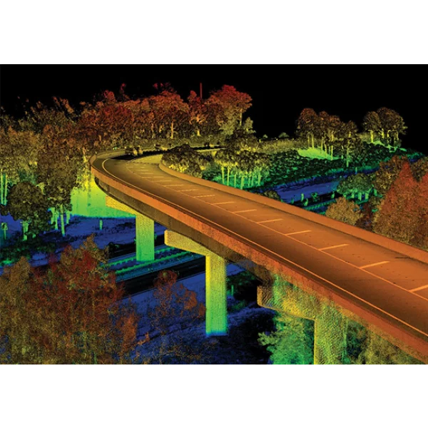
3d Lidar Scanning Services In Ranchi


Details of 3D Lidar Scanning & Data Processing
By keeping track of the latest market developments, we offer advanced 3D LiDAR Scanning Services for accurate and fast spatial data collection. These services generate precise point cloud data for surveying, mapping, and planning applications. LiDAR scanning reduces manual effort and delivers reliable results even in complex environments. Each project is processed with proper validation to ensure accuracy. Clients in Ranchi depend on these services for efficient surveying and high-quality digital outputs.
Technical Benefits
- High-accuracy spatial data
- Rapid data acquisition
- Suitable for complex terrains
- Reduced field survey time
- Reliable digital deliverables
Usage Applications
- Land and topographic surveys
- Infrastructure planning
- Mining and quarry mapping
- Urban development
Searching for 3D LiDAR Scanning Services in Ranchi?
Reach out to us for advanced surveying solutions.
Offered Service

3D Lidar Scanning & Data Processing
3D Lidar Scanning & Data ProcessingFor A Variety Of Reasons, The Usage Of Lidar Data Processing Has Exploded In Recent Years. Lidar Technology Aided In Obtaining Higher-quality Data Than Previous Low-cost Photogrammetric Approaches. As A Result, Automatically Gathering Measurements In A Dense Manner, Has Resulted In A Significant Accomplishment. The Advancement Of Laser Scanning Gear Has Been Astounding. For Quite Some Time, Suncad Has Been At The Forefront Of LiDAR Data Processi... Read more3d Lidar Scanning Services In Ghaziabad

Being A Leading Firm In This Industry, We Provide Advanced 3D LiDAR Scanning Services In Ghaziabad, Designed For Precise Topographical Mapping And Spatial Data Acquisition. Utilizing High-resolution LiDAR Technology, Our Services Deliver Accurate Terrain Models, Point Cloud Data, And 3D Representations For Infrastructure, Construction, And Urban Planning Projects. With Trained Professionals And State-of-the-art Equipment, We Ensure Quick Turnaround, High Accuracy, And Cost-effective Solutions. Continue
3d Lidar Scanning Services In Surat
Backed By Advanced Surveying Expertise, We Offer Precision-driven 3D LiDAR Scanning Services For Industrial, Construction, And Architectural Applications In Surat. Using High-resolution LiDAR Equipment, Our Team Captures Detailed Surface Data, Structural Geometry, And Terrain Profiles With Exceptional Accuracy. Each Project Undergoes Strict Quality Checks To Ensure Reliable Output, Faster Processing, And Precise Digital Documentation. Ideal For Infrastructure Planning, Renovation, Land Assessmen Continue
3d Lidar Scanning Services In Meerut

By Leveraging Advanced Laser Scanning Technology, We Provide Reliable 3D LiDAR Scanning Services In Meerut For Infrastructure, Industrial, And Land Survey Applications. Our Services Are Executed Using High‑precision LiDAR Equipment Operated By Skilled Professionals To Capture Accurate Spatial Data In Minimal Time. This Solution Is Ideal For Large‑scale Mapping, Construction Planning, And Asset Documentation.Recognized For Accuracy And Speed, Our LiDAR Scanning Services Deliver High‑resol Continue