- Home
- About Us
- Products
- Services
- 3D Scanning Services
- 3D Inspection Service
- Reverse Engineering Services
- Lieca 3D Laser Tracker Services
- 3D Plant Scanning
- CNC Machine Laser Calibration Service
- Engineering Analysis And Simulation Services
- 3D Printing Service
- CAM Milling Services
- CAM Turning Services
- Software Sales
- Education / Training
- Statue Of 3D Scanning Services
- RTC 360 Plant & Refinery Scanning Services
- CNC Machine Laser Calibration & Operating Service
- Best 3D Printing Service
- Updates
- Gallery
- Contact Us
3d Terrestrial Scanning Service In Jabalpur


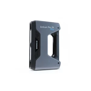
Details of EinScan-Pro 2X Plus
We work with 3D terrestrial scanning services in Jabalpur, bringing hands-on knowledge and practical tools to every job. It’s not just about the tech; it's how we fit it into the real needs of each customer that matters. The system we use helps track field operations from start to finish, making sure scans are accurate and workflows stay smooth.
Fieldwork can be tricky when conditions shift suddenly or equipment faces wear and tear. Our model focuses on keeping service stable by using regular checks and controls to spot problems early. This way, downtime stays low even if issues pop up during a project.
Planning for long-term use means thinking beyond today’s scan data collection. We link scanning results directly into bigger organizational goals like infrastructure updates or maintenance schedules. This connection makes scanned data more useful for decision makers and supports ongoing strategy shifts based on actual site changes.
Offered Product

EinScan-Pro 2X Plus
All In One Versatility : Offer Both Portability And High-accuracy Because Of Its Four Versatile Operating Modes. Multi-applications : Create An Accurate, 3D Printable Model Of Existing Physical Objects—whether It Be An Industrial Part, A Sculpture, A Delicate Family Heirloom, An Antique Toy, A Hard-to-find Replacement Part For Your Tool Kit Or Even A Scan Of Your Own Body Parts.High Speed : In The Handheld Scan Mode, The Scan Speed Is 10 Fps (frames Per Second) And In The Automatic A... Read more3d Terrestrial Scanning Service In Gwalior

Each Task Under The 3D Terrestrial Scanning Service In Gwalior Gets Careful Attention Based On Client Needs, Making The Work Straightforward And Clear. We Focus On Exact Data Capture Using High-grade Laser Scanners To Map Large Outdoor Areas Accurately. The Goal Is To Help Clients Get Usable, Detailed Scans Without Fuss.Advanced Documentation WorkflowThe Scanning Process Includes Multiple Steps That Cover Site Prep, Scan Planning, Data Acquisition, And Post-processing. Using Advanced Software To Continue
3d Terrestrial Scanning Service In Aurangabad

Keeping A Solid Reputation Means Steady Work And Deep Know-how In 3d Terrestrial Scanning Service For Aurangabad. Our Team Focuses On Clear Data Capture That Lasts Beyond First Use. We Handle The Tough Parts Of Large-area Scans, Offering Reliable Results With Accurate Details You Can Count On.Measurement Governance Is No Simple Task Here. It's About Managing The Full Cycle: Setting Up The Scanners, Checking Calibration Regularly, Handling Data Securely, Then Reviewing Outcomes To Catch Errors Ea Continue
3d Terrestrial Scanning Service In Patna
Speed Matters. Getting Your Project Moving Faster Takes More Than Just Tools; It Needs Focused 3D Terrestrial Scanning Service In Patna, Built For Results That Cut Down Wait Times And Deliver Precise Data Quickly. We Handle The Whole Flow From Capturing Raw Scans To Delivering Structured Outputs You Can Use Directly In Modeling Or Inspection.Documentation Is Often Scattered, Incomplete, Or Outdated. Our Approach Builds A Clear Structural Data Lifecycle Documentation Roadmap, Which Tracks Each St Continue