- Home
- About Us
- Products
- Services
- 3D Scanning Services
- 3D Inspection Service
- Reverse Engineering Services
- Lieca 3D Laser Tracker Services
- 3D Plant Scanning
- CNC Machine Laser Calibration Service
- Engineering Analysis And Simulation Services
- 3D Printing Service
- CAM Milling Services
- CAM Turning Services
- Software Sales
- Education / Training
- Statue Of 3D Scanning Services
- RTC 360 Plant & Refinery Scanning Services
- CNC Machine Laser Calibration & Operating Service
- Best 3D Printing Service
- Updates
- Gallery
- Contact Us
3d Terrestrial Scanning Service In Nagpur


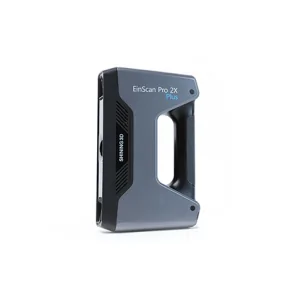
Details of EinScan-Pro 2X Plus
3D terrestrial scanning service in Nagpur offers precise data capture that fits project needs and delivers consistent results. This technology records detailed spatial information, which helps industries reduce errors and speed up workflows.
Managing the data lifecycle is crucial for scanning projects. From capturing raw point clouds to processing and integrating them into CAD or BIM models, every step must align with the project's timeline and accuracy requirements. We track changes carefully while keeping data ready for future use or rework.
The workforce handling these tasks requires both technical skill and practical experience. Operators trained in handling laser scanners, plus experts in software tools for post-processing, form a core team. Besides scanning skills, field knowledge about site conditions in locations like Nagpur matters—dust and heat affect equipment performance (which we've seen during summer months here).
Starting a collaboration means understanding your growth plans too. Our approach stays flexible to scale resources as needed without compromising quality or deadlines. By syncing with your teams early on, we adjust delivery methods or output formats so they fit smoothly into existing systems or upcoming expansions.
Offered Product

EinScan-Pro 2X Plus
All In One Versatility : Offer Both Portability And High-accuracy Because Of Its Four Versatile Operating Modes. Multi-applications : Create An Accurate, 3D Printable Model Of Existing Physical Objects—whether It Be An Industrial Part, A Sculpture, A Delicate Family Heirloom, An Antique Toy, A Hard-to-find Replacement Part For Your Tool Kit Or Even A Scan Of Your Own Body Parts.High Speed : In The Handheld Scan Mode, The Scan Speed Is 10 Fps (frames Per Second) And In The Automatic A... Read moreDrone Scanning Services In Meerut
By Keeping Track Of The Latest Market Developments, We Offer High-precision Drone Scanning Services In Meerut. These Services Are Systematically Performed Using High-resolution Drones And Advanced Aerial Data Processing Software To Capture Detailed Site Information. Ideal For Construction, Mining, And Land Surveys, Drone Scanning Enables Fast Data Collection, Improved Safety, And Cost Efficiency. All Captured Data Is Thoroughly Analyzed To Deliver Accurate Maps, Point Clouds, And Actionable Insi Continue
3d Terrestrial Scanning Service In Rajkot

3D Terrestrial Scanning Service In Rajkot Gets Handled Effectively By Following A Thorough Approach That Checks All Requirements Until Completion. We Cover Every Detail From Site Measurement To Final Data Delivery, Making Sure Nothing Is Missed For Your Industrial Projects.Capturing Large-scale Environments Needs The Right Tools And Care. Our Process Begins With Setting Up Precise Scanners To Gather Detailed Spatial Data Over Extensive Areas, Which Helps Create Accurate Models Later On. This Ste Continue
3d Terrestrial Scanning Service In Gwalior

Each Task Under The 3D Terrestrial Scanning Service In Gwalior Gets Careful Attention Based On Client Needs, Making The Work Straightforward And Clear. We Focus On Exact Data Capture Using High-grade Laser Scanners To Map Large Outdoor Areas Accurately. The Goal Is To Help Clients Get Usable, Detailed Scans Without Fuss.Advanced Documentation WorkflowThe Scanning Process Includes Multiple Steps That Cover Site Prep, Scan Planning, Data Acquisition, And Post-processing. Using Advanced Software To Continue