- Home
- About Us
- Products
- Services
- 3D Scanning Services
- 3D Inspection Service
- Reverse Engineering Services
- Lieca 3D Laser Tracker Services
- 3D Plant Scanning
- CNC Machine Laser Calibration Service
- Engineering Analysis And Simulation Services
- 3D Printing Service
- CAM Milling Services
- CAM Turning Services
- Software Sales
- Education / Training
- Statue Of 3D Scanning Services
- RTC 360 Plant & Refinery Scanning Services
- CNC Machine Laser Calibration & Operating Service
- Best 3D Printing Service
- Updates
- Gallery
- Contact Us
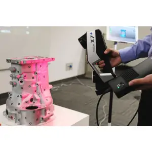
3d Terrestrial Scanning Services In Surat


Details of 3D Scanning Services
With the support of modern technology, we are engaged in providing dependable 3D Terrestrial Scanning Services in Surat. These services are performed using high-precision scanners to deliver accurate spatial data for industrial, commercial, and infrastructure projects. Our team follows strict quality procedures to ensure reliable measurements, detailed point clouds, and error-free outputs. The scanned data helps reduce rework, save time, and improve planning efficiency. Clients can avail these services at cost-effective rates.
Scanning Performance Benefits
- High-accuracy measurements
- Fast data capture
- Reduced site errors
- Suitable for complex structures
- Professional-grade output
Get Accurate Site Data – Enquire Now!
Offered Service

3D Scanning Services
To Meet The Specific Preferences Of Clients, We Have Betrothed To Offer An Assorted Range Of 3D Laser Scanning Services. These Are Carried Out By Using Modern Technology By Our Professionals, To Ensure Systematic Execution. Rendered By Us In Accordance With International Standards, The Quality Of These 3D Laser Scanning Services Is Never Compromised At Our End.Other Details:Carried By Qualified ProfessionalsAdvanced Multi-scan Merging To Create Complete, Non-overlapping Polygon Mesh M... Read moreDrone Scanning Services In Indore
With Cutting-edge Aerial Mapping Capabilities, We Deliver Fast And Accurate Drone Scanning Services Across Indore. Our Drones Are Equipped With High-resolution Sensors That Capture Terrain, Structures, And Site Conditions With Exceptional Clarity. The Captured Data Is Processed By Skilled Technicians To Generate Maps, 3D Models, And Volumetric Reports. Every Project Is Reviewed For Accuracy, Ensuring Dependable Results For Construction, Mining, Land Development, And Inspection Applications.Aer Continue
Heritage Scanning Services In Bikaner

Backed By Extensive Field Experience, We Are Actively Involved In Offering Reliable Heritage Scanning Services In Bikaner. These Services Are Carried Out Using Advanced Laser Scanning Equipment To Accurately Capture Historic Structures Without Physical Damage. Our Skilled Professionals Ensure Precise Documentation, Dimensional Accuracy, And Detailed Data Output Suitable For Conservation And Restoration Planning. Each Project Is Carefully Executed And Quality-checked To Meet Industry And Heritage Continue
3d Bim Modelling Services In Agra

Leveraging On Advanced Digital Engineering Expertise, We Are A Trusted 3D BIM Modelling Services Provider In Agra. Our 3D BIM Models Help Architects, Engineers, And Contractors Visualize Projects Accurately Before Execution. Using Industry-standard BIM Software, We Create Detailed Architectural, Structural, And MEP Models That Reduce Design Errors And Improve Coordination. Our Services Support Efficient Planning, Clash Detection, And Smooth Project Execution For Residential, Commercial, And Indu Continue