- Home
- About Us
- Products
- Services
- 3D Scanning Services
- 3D Inspection Service
- Reverse Engineering Services
- Lieca 3D Laser Tracker Services
- 3D Plant Scanning
- CNC Machine Laser Calibration Service
- Engineering Analysis And Simulation Services
- 3D Printing Service
- CAM Milling Services
- CAM Turning Services
- Software Sales
- Education / Training
- Statue Of 3D Scanning Services
- RTC 360 Plant & Refinery Scanning Services
- CNC Machine Laser Calibration & Operating Service
- Best 3D Printing Service
- Updates
- Gallery
- Contact Us
3d Terrestrial Scanning Service In Ghaziabad


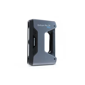
Details of EinScan-Pro 2X Plus
Delivering 3d terrestrial scanning service in Ghaziabad helps clients keep their projects moving without pause despite the rising demands of accurate data capture and site documentation. The technology gathers precise spatial information quickly, avoiding delays caused by traditional survey methods.
Our approach focuses on managing the entire survey lifecycle—from initial planning to final data delivery—making sure each step fits client needs and timelines. This includes scheduling scans, preparing the site, executing measurements with laser scanners, processing raw data into usable models, and handing off files that integrate easily with CAD or BIM systems. It’s not just about scanning but how well we coordinate these stages.
Starting Off Right for New Clients
We arrange a kickoff meeting to outline project goals, discuss specific requirements like scan density or areas of interest, and define key milestones so everyone shares the same expectations early on.
Our tools include high-end terrestrial laser scanners that can capture millions of points per second with millimeter accuracy.
Clients get processed point clouds or meshes in common formats ready to use immediately within their workflows.
The way we collaborate suits complex projects where multiple teams work together. We align closely with client engineers, architects, or contractors via regular updates and shared access to intermediate results so problems surface early. This openness keeps rework minimal even when changes arise on-site or in design scope.
Then there’s the matter of adapting rapidly when sites evolve fast during construction phases. Our flexible scanning schedules and quick turnaround times let us respond promptly as conditions change without holding back progress elsewhere.
The goal is growth through steady reliability rather than flashy claims. We measure success by how well our output supports decisions down the line—whether it’s clash detection in BIM models or precise volume calculations at refineries (a note here: volume checks often catch errors missed by manual measurement).
Offered Product

EinScan-Pro 2X Plus
All In One Versatility : Offer Both Portability And High-accuracy Because Of Its Four Versatile Operating Modes. Multi-applications : Create An Accurate, 3D Printable Model Of Existing Physical Objects—whether It Be An Industrial Part, A Sculpture, A Delicate Family Heirloom, An Antique Toy, A Hard-to-find Replacement Part For Your Tool Kit Or Even A Scan Of Your Own Body Parts.High Speed : In The Handheld Scan Mode, The Scan Speed Is 10 Fps (frames Per Second) And In The Automatic A... Read more3d Terrestrial Scanning Service In Jabalpur
We Work With 3D Terrestrial Scanning Services In Jabalpur, Bringing Hands-on Knowledge And Practical Tools To Every Job. It’s Not Just About The Tech; It's How We Fit It Into The Real Needs Of Each Customer That Matters. The System We Use Helps Track Field Operations From Start To Finish, Making Sure Scans Are Accurate And Workflows Stay Smooth.Fieldwork Can Be Tricky When Conditions Shift Suddenly Or Equipment Faces Wear And Tear. Our Model Focuses On Keeping Service Stable By Using Regular C Continue
3d Terrestrial Scanning Service In Patna

Speed Matters. Getting Your Project Moving Faster Takes More Than Just Tools; It Needs Focused 3D Terrestrial Scanning Service In Patna, Built For Results That Cut Down Wait Times And Deliver Precise Data Quickly. We Handle The Whole Flow From Capturing Raw Scans To Delivering Structured Outputs You Can Use Directly In Modeling Or Inspection.Documentation Is Often Scattered, Incomplete, Or Outdated. Our Approach Builds A Clear Structural Data Lifecycle Documentation Roadmap, Which Tracks Each St Continue
Drone Scanning Service In Goa

Known For Our Skills, We Offer Drone Scanning Service In Goa Made To Back Your Project Goals. Drone Scanning Cuts Down On Manual Checks And Speeds Up Data Gathering With Aerial Views That Show Even Hard-to-reach Spots. We Track Every Phase Of The Asset's Life Cycle Digitally, Helping You Spot Issues Early And Plan Repairs Better.Keeping Business Steady Needs More Than Just Tech—it Needs A Clear System To Manage Risks Linked With Drones Like Safety Rules, Data Privacy, And Flight Permissions. W Continue