- Home
- About Us
- Products
- Services
- 3D Scanning Services
- 3D Inspection Service
- Reverse Engineering Services
- Lieca 3D Laser Tracker Services
- 3D Plant Scanning
- CNC Machine Laser Calibration Service
- Engineering Analysis And Simulation Services
- 3D Printing Service
- CAM Milling Services
- CAM Turning Services
- Software Sales
- Education / Training
- Statue Of 3D Scanning Services
- RTC 360 Plant & Refinery Scanning Services
- CNC Machine Laser Calibration & Operating Service
- Best 3D Printing Service
- Updates
- Gallery
- Contact Us
3d Terrestrial Scanning Service In Greater Noida


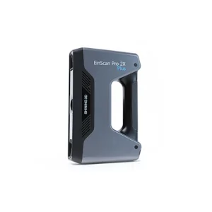
Details of EinScan-Pro 2X Plus
Responsibility for delivering high-quality 3D terrestrial scanning service in Greater Noida rests on practical experience combined with an understanding of local business conditions. We handle complex spatial data collection using ground-based laser scanners to capture precise geometry and surface details for various industrial and infrastructure projects. The process demands careful planning to cover all critical areas while managing time and resource constraints common in urban environments.
Our digital spatial lifecycle management strategy involves capturing, processing, and managing point cloud data that supports downstream tasks like BIM modelling, plant design, and asset documentation. This approach reduces rework by providing reliable as-built information early on. Managing large datasets requires robust software tools and skilled operators who can work with raw scans, stitch multiple views together, filter noise, and produce usable outputs under tight deadlines.
Strategic Investment Capability Model
We invest steadily in latest terrestrial scanning hardware to maintain measurement accuracy over long ranges, even in challenging outdoor settings where lighting or weather conditions vary. For example, a recent project involved scanning refinery pipelines spread across uneven terrain requiring repeat visits due to ambient dust (which often complicates scan quality). Our equipment's durability lets us collect consistent data despite such obstacles.
Software upgrades are equally important; they allow advanced registration techniques that reduce manual alignment errors. Plus, automation scripts speed up point cloud processing so results reach clients faster than usual workflows. These investments shape our ability to serve industries needing quick turnaround without sacrificing precision.
Join Our Visionary Leadership Alliance
We welcome partnerships with engineering firms seeking dependable terrestrial scanning solutions that integrate into broader design and maintenance systems seamlessly. Collaborating closely during early project phases helps identify key scanning targets minimizing field time but maximizing coverage quality—something many overlook until late stages causing costly delays. Our expertise in 3D scanning merges well with client teams aiming for digital transformation in asset management or construction monitoring.
Offered Product

EinScan-Pro 2X Plus
All In One Versatility : Offer Both Portability And High-accuracy Because Of Its Four Versatile Operating Modes. Multi-applications : Create An Accurate, 3D Printable Model Of Existing Physical Objects—whether It Be An Industrial Part, A Sculpture, A Delicate Family Heirloom, An Antique Toy, A Hard-to-find Replacement Part For Your Tool Kit Or Even A Scan Of Your Own Body Parts.High Speed : In The Handheld Scan Mode, The Scan Speed Is 10 Fps (frames Per Second) And In The Automatic A... Read moreDrone Scanning Service In Goa
Known For Our Skills, We Offer Drone Scanning Service In Goa Made To Back Your Project Goals. Drone Scanning Cuts Down On Manual Checks And Speeds Up Data Gathering With Aerial Views That Show Even Hard-to-reach Spots. We Track Every Phase Of The Asset's Life Cycle Digitally, Helping You Spot Issues Early And Plan Repairs Better.Keeping Business Steady Needs More Than Just Tech—it Needs A Clear System To Manage Risks Linked With Drones Like Safety Rules, Data Privacy, And Flight Permissions. W Continue
3d Terrestrial Scanning Service In Indore

Delivering Clear-cut Strategies For 3d Terrestrial Scanning Service In Indore Takes More Than Just Good Equipment. We Handle Every Step From Setup To Data Capture With Focus On Ease And Efficiency. The Goal Is To Collect Precise Spatial Data That Supports Engineering, Construction, And Infrastructure Projects Without Delays.Data Accuracy Can Make Or Break Project Timelines. Our Approach Includes Careful Planning Of Scan Locations And Paths, Ensuring Minimal Rework. Using Advanced Laser Scanners Continue
3d Terrestrial Scanning Service In Coimbatore

Offering Reliable 3D Terrestrial Scanning Service In Coimbatore Calls For Sharp Execution And A Clear Hold On Quality Throughout The Process. We Handle Everything From Initial Site Setup To Data Delivery With Care, Making Sure Each Step Sticks To Set Standards.The Scanning Journey Starts With Understanding Client Needs On Location, Then Setting Up The Scanner Properly For The Environment. After Capturing The Raw Point Clouds, We Clean And Register Data To Form Usable Models That Fit Client Deman Continue