- Home
- About Us
- Products
- Services
- 3D Scanning Services
- 3D Inspection Service
- Reverse Engineering Services
- Lieca 3D Laser Tracker Services
- 3D Plant Scanning
- CNC Machine Laser Calibration Service
- Engineering Analysis And Simulation Services
- 3D Printing Service
- CAM Milling Services
- CAM Turning Services
- Software Sales
- Education / Training
- Statue Of 3D Scanning Services
- RTC 360 Plant & Refinery Scanning Services
- CNC Machine Laser Calibration & Operating Service
- Best 3D Printing Service
- Updates
- Gallery
- Contact Us
3d Terrestrial Scanning Service In Indore


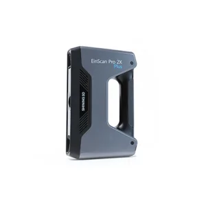
Details of EinScan-Pro 2X Plus
Delivering clear-cut strategies for 3d terrestrial scanning service in Indore takes more than just good equipment. We handle every step from setup to data capture with focus on ease and efficiency. The goal is to collect precise spatial data that supports engineering, construction, and infrastructure projects without delays.
Data accuracy can make or break project timelines. Our approach includes careful planning of scan locations and paths, ensuring minimal rework. Using advanced laser scanners and software, we map large outdoor areas quickly while maintaining high detail levels. Then there's the matter of managing huge datasets — we use robust processing tools to turn raw scans into usable 3d models or point clouds that clients can work with immediately.
Sustainability plays a role here too. Minimizing site visits reduces fuel use and disturbance to local environments around Indore project sites. Plus, digital records mean fewer physical surveys are needed over time, saving resources in the long run. Being mindful about this fits well with growing demands for greener operations across industries.
We also tap into our network of experts—surveyors, CAD engineers, GIS analysts—to support complex jobs that require integrated workflows beyond scanning alone. This network helps us offer solutions tailored exactly to client needs instead of one-size-fits-all answers (which rarely fit). Engaging closely with partners keeps communication clear and speeds up problem solving during fieldwork or post-processing phases.
Offered Product

EinScan-Pro 2X Plus
All In One Versatility : Offer Both Portability And High-accuracy Because Of Its Four Versatile Operating Modes. Multi-applications : Create An Accurate, 3D Printable Model Of Existing Physical Objects—whether It Be An Industrial Part, A Sculpture, A Delicate Family Heirloom, An Antique Toy, A Hard-to-find Replacement Part For Your Tool Kit Or Even A Scan Of Your Own Body Parts.High Speed : In The Handheld Scan Mode, The Scan Speed Is 10 Fps (frames Per Second) And In The Automatic A... Read more3d Terrestrial Scanning Service In Ghaziabad

Delivering 3d Terrestrial Scanning Service In Ghaziabad Helps Clients Keep Their Projects Moving Without Pause Despite The Rising Demands Of Accurate Data Capture And Site Documentation. The Technology Gathers Precise Spatial Information Quickly, Avoiding Delays Caused By Traditional Survey Methods.Our Approach Focuses On Managing The Entire Survey Lifecycle—from Initial Planning To Final Data Delivery—making Sure Each Step Fits Client Needs And Timelines. This Includes Scheduling Scans, Pre Continue
Drone Scanning Service In Goa

Known For Our Skills, We Offer Drone Scanning Service In Goa Made To Back Your Project Goals. Drone Scanning Cuts Down On Manual Checks And Speeds Up Data Gathering With Aerial Views That Show Even Hard-to-reach Spots. We Track Every Phase Of The Asset's Life Cycle Digitally, Helping You Spot Issues Early And Plan Repairs Better.Keeping Business Steady Needs More Than Just Tech—it Needs A Clear System To Manage Risks Linked With Drones Like Safety Rules, Data Privacy, And Flight Permissions. W Continue
3d Terrestrial Scanning Service In Greater Noida
Responsibility For Delivering High-quality 3D Terrestrial Scanning Service In Greater Noida Rests On Practical Experience Combined With An Understanding Of Local Business Conditions. We Handle Complex Spatial Data Collection Using Ground-based Laser Scanners To Capture Precise Geometry And Surface Details For Various Industrial And Infrastructure Projects. The Process Demands Careful Planning To Cover All Critical Areas While Managing Time And Resource Constraints Common In Urban Environments.Ou Continue