- Home
- About Us
- Products
- Services
- 3D Scanning Services
- 3D Inspection Service
- Reverse Engineering Services
- Lieca 3D Laser Tracker Services
- 3D Plant Scanning
- CNC Machine Laser Calibration Service
- Engineering Analysis And Simulation Services
- 3D Printing Service
- CAM Milling Services
- CAM Turning Services
- Software Sales
- Education / Training
- Statue Of 3D Scanning Services
- RTC 360 Plant & Refinery Scanning Services
- CNC Machine Laser Calibration & Operating Service
- Best 3D Printing Service
- Updates
- Gallery
- Contact Us
3d Terrestrial Scanning Service In Muzaffarpur


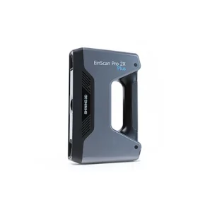
Details of EinScan-Pro 2X Plus
We are the reliable 3D terrestrial scanning service provider in Muzaffarpur, committed to delivering quality results that meet your business needs every time with clear communication and timely completion. Our approach focuses on capturing accurate spatial data using advanced scanning technology suited for complex industrial and infrastructure projects.
Scanning large sites often faces issues like environmental interference and access restrictions. We manage these by using portable laser scanners and fixed systems together, combining point cloud data for a complete picture of the site layout and conditions. This workflow allows ongoing monitoring of plant conditions without stopping operations, reducing downtime significantly during inspections.
Project timelines tighten when coordination between teams is weak. We support clients by integrating scanned data into BIM models early in the process. This helps engineers visualize current state details before design or maintenance work begins, cutting guesswork and errors that cause delays or rework. Real-time updates on progress keep everyone aligned on what’s done versus planned.
Aligning for business growth means adopting tools that let you react quickly to site changes and regulatory demands. Using terrestrial scanning data in Muzaffarpur's industrial setups helps improve planning accuracy while saving costs tied to manual surveys or outdated maps. Our scans provide a solid base for future expansions or audits without needing repeated field visits (which get tricky during seasonal rains here).
Offered Product

EinScan-Pro 2X Plus
All In One Versatility : Offer Both Portability And High-accuracy Because Of Its Four Versatile Operating Modes. Multi-applications : Create An Accurate, 3D Printable Model Of Existing Physical Objects—whether It Be An Industrial Part, A Sculpture, A Delicate Family Heirloom, An Antique Toy, A Hard-to-find Replacement Part For Your Tool Kit Or Even A Scan Of Your Own Body Parts.High Speed : In The Handheld Scan Mode, The Scan Speed Is 10 Fps (frames Per Second) And In The Automatic A... Read more3d Terrestrial Scanning Service In Coimbatore

Offering Reliable 3D Terrestrial Scanning Service In Coimbatore Calls For Sharp Execution And A Clear Hold On Quality Throughout The Process. We Handle Everything From Initial Site Setup To Data Delivery With Care, Making Sure Each Step Sticks To Set Standards.The Scanning Journey Starts With Understanding Client Needs On Location, Then Setting Up The Scanner Properly For The Environment. After Capturing The Raw Point Clouds, We Clean And Register Data To Form Usable Models That Fit Client Deman Continue
3d Terrestrial Scanning Service In Surat
Providing 3D Terrestrial Scanning Service In Surat Involves More Than Just Delivery; It Means Fostering Ongoing Collaboration That Adapts To Client Needs. We Focus On The Entire Digital Engineering Lifecycle, Capturing Real-world Data Accurately And Feeding It Into Design And Analysis Workflows. This Approach Helps Manage Project Changes Better And Reduces Rework Later.The Backbone Of Good Scanning Lies In Strong Digital Infrastructure. Our Systems Handle Large Point Clouds Swiftly, Making Sure Continue
Drone Scanning Service In Vadodara

Missed Deadlines Or Subpar Work From Other Providers Of Drone Scanning Service In Vadodara Can Cause Setbacks; Our Focus Is On Reliability And Accuracy At Every Step. We Handle Projects With Timely Data Capture And Precise Processing To Avoid Delays. Drone Scanning Brings Speed But Also Requires Skilled Operation To Get Consistent Results.Drone Scanning Works Best When Site Conditions Are Documented Properly Before Flights. Clear Weather, Proper Ground Control Points, And Detailed Flight Plans A Continue