- Home
- About Us
- Products
- Services
- 3D Scanning Services
- 3D Inspection Service
- Reverse Engineering Services
- Lieca 3D Laser Tracker Services
- 3D Plant Scanning
- CNC Machine Laser Calibration Service
- Engineering Analysis And Simulation Services
- 3D Printing Service
- CAM Milling Services
- CAM Turning Services
- Software Sales
- Education / Training
- Statue Of 3D Scanning Services
- RTC 360 Plant & Refinery Scanning Services
- CNC Machine Laser Calibration & Operating Service
- Best 3D Printing Service
- Updates
- Gallery
- Contact Us
3d Terrestrial Scanning Service In Surat


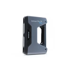
Details of EinScan-Pro 2X Plus
Providing 3D terrestrial scanning service in Surat involves more than just delivery; it means fostering ongoing collaboration that adapts to client needs. We focus on the entire digital engineering lifecycle, capturing real-world data accurately and feeding it into design and analysis workflows. This approach helps manage project changes better and reduces rework later.
The backbone of good scanning lies in strong digital infrastructure. Our systems handle large point clouds swiftly, making sure data stays consistent across platforms. In Surat's busy industrial setups, this matters because delays or errors could disrupt schedules or cause costly mistakes down the line. Using reliable hardware combined with smart software ensures smooth integration into client systems without adding overhead.
Then there's the matter of turning raw scans into useful models. We support vision-led organizational excellence by aligning scanned data with business goals—whether for plant maintenance, retrofit projects, or quality checks. It’s not about just delivering files but helping stakeholders visualize current states and spot issues early on. Clear communication and tailored reporting play a big role here to keep everyone on the same page.
Offered Product

EinScan-Pro 2X Plus
All In One Versatility : Offer Both Portability And High-accuracy Because Of Its Four Versatile Operating Modes. Multi-applications : Create An Accurate, 3D Printable Model Of Existing Physical Objects—whether It Be An Industrial Part, A Sculpture, A Delicate Family Heirloom, An Antique Toy, A Hard-to-find Replacement Part For Your Tool Kit Or Even A Scan Of Your Own Body Parts.High Speed : In The Handheld Scan Mode, The Scan Speed Is 10 Fps (frames Per Second) And In The Automatic A... Read more3d Terrestrial Scanning Service In Greater Noida
Responsibility For Delivering High-quality 3D Terrestrial Scanning Service In Greater Noida Rests On Practical Experience Combined With An Understanding Of Local Business Conditions. We Handle Complex Spatial Data Collection Using Ground-based Laser Scanners To Capture Precise Geometry And Surface Details For Various Industrial And Infrastructure Projects. The Process Demands Careful Planning To Cover All Critical Areas While Managing Time And Resource Constraints Common In Urban Environments.Ou Continue
3d Terrestrial Scanning Service In Coimbatore

Offering Reliable 3D Terrestrial Scanning Service In Coimbatore Calls For Sharp Execution And A Clear Hold On Quality Throughout The Process. We Handle Everything From Initial Site Setup To Data Delivery With Care, Making Sure Each Step Sticks To Set Standards.The Scanning Journey Starts With Understanding Client Needs On Location, Then Setting Up The Scanner Properly For The Environment. After Capturing The Raw Point Clouds, We Clean And Register Data To Form Usable Models That Fit Client Deman Continue
3d Terrestrial Scanning Service In Muzaffarpur

We Are The Reliable 3D Terrestrial Scanning Service Provider In Muzaffarpur, Committed To Delivering Quality Results That Meet Your Business Needs Every Time With Clear Communication And Timely Completion. Our Approach Focuses On Capturing Accurate Spatial Data Using Advanced Scanning Technology Suited For Complex Industrial And Infrastructure Projects.Scanning Large Sites Often Faces Issues Like Environmental Interference And Access Restrictions. We Manage These By Using Portable Laser Scanners Continue