- Home
- About Us
- Products
- Services
- 3D Scanning Services
- 3D Inspection Service
- Reverse Engineering Services
- Lieca 3D Laser Tracker Services
- 3D Plant Scanning
- CNC Machine Laser Calibration Service
- Engineering Analysis And Simulation Services
- 3D Printing Service
- CAM Milling Services
- CAM Turning Services
- Software Sales
- Education / Training
- Statue Of 3D Scanning Services
- RTC 360 Plant & Refinery Scanning Services
- CNC Machine Laser Calibration & Operating Service
- Best 3D Printing Service
- Updates
- Gallery
- Contact Us
Drone Scanning Service In Aurangabad


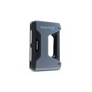
Details of EinScan-Pro 2X Plus
We take responsibility as a dedicated provider of drone scanning services in Aurangabad, ensuring every step aligns with your business goals through tested procedures. Using drones for scanning helps us reach difficult spots fast and gather data that traditional tools miss. We manage the entire process carefully to give you clear results that suit your project needs.
Digital spatial lifecycle integration means we don't just scan; we link data from start to end. Capturing the site with drones is just the first move. Then we bring this info into digital models and workflows that support maintenance, planning, and further updates over time. This ongoing cycle cuts errors and speeds decisions on site.
Standardizing performance across teams is key when dealing with large sites or repeated jobs. We follow strict checklists for drone flights, data capture quality, and post-processing steps. This makes sure each scan matches earlier ones and keeps your records reliable no matter how many scans are done or which team handles them next.
Align For Professional Progress
Clients need partners who can grow with their needs. We focus on keeping our staff trained on new drone tech plus software advances so skills don’t lag behind demands. That way, projects stay smooth even as requirements change or expand - whether it's bigger coverage areas or higher detail levels needed at short notice.
Offered Product

EinScan-Pro 2X Plus
All In One Versatility : Offer Both Portability And High-accuracy Because Of Its Four Versatile Operating Modes. Multi-applications : Create An Accurate, 3D Printable Model Of Existing Physical Objects—whether It Be An Industrial Part, A Sculpture, A Delicate Family Heirloom, An Antique Toy, A Hard-to-find Replacement Part For Your Tool Kit Or Even A Scan Of Your Own Body Parts.High Speed : In The Handheld Scan Mode, The Scan Speed Is 10 Fps (frames Per Second) And In The Automatic A... Read more3d Terrestrial Scanning Service In Muzaffarpur

We Are The Reliable 3D Terrestrial Scanning Service Provider In Muzaffarpur, Committed To Delivering Quality Results That Meet Your Business Needs Every Time With Clear Communication And Timely Completion. Our Approach Focuses On Capturing Accurate Spatial Data Using Advanced Scanning Technology Suited For Complex Industrial And Infrastructure Projects.Scanning Large Sites Often Faces Issues Like Environmental Interference And Access Restrictions. We Manage These By Using Portable Laser Scanners Continue
Drone Scanning Service In Vadodara

Missed Deadlines Or Subpar Work From Other Providers Of Drone Scanning Service In Vadodara Can Cause Setbacks; Our Focus Is On Reliability And Accuracy At Every Step. We Handle Projects With Timely Data Capture And Precise Processing To Avoid Delays. Drone Scanning Brings Speed But Also Requires Skilled Operation To Get Consistent Results.Drone Scanning Works Best When Site Conditions Are Documented Properly Before Flights. Clear Weather, Proper Ground Control Points, And Detailed Flight Plans A Continue
3d Terrestrial Scanning Service In Kolkata
Choosing Us For Your 3D Terrestrial Scanning Needs In Kolkata Means Working With A Partner Who Values Ethics And Openness Above All Else. We Focus On Accuracy And Timely Delivery, Making Sure Projects Move Forward Without Delays. Our Service Includes Detailed 3D Scans That Capture Large Sites Or Objects With High Precision.Managing Complex Infrastructure Calls For Smart Control. Our Approach To Lifecycle Management Uses Advanced Scanning Methods To Create Clear Records Of Current Conditions. Thi Continue